BaudenSteig circular route No. 6 Wieda-Stöberhai


- 2:45 h
- 8.74 km
- 333 m
- 334 m
- 379 m
- 714 m
- 335 m
- Start: Car park at the outskirts of Wieda (on the left), L601 towards Braunlage
- Destination: Car park at the outskirts of Wieda (on the left), L601 towards Braunlage
All BaudenSteig circular routes touch the BaudenSteig and convey the feeling of following this beautiful long-distance trail for a while.

Good to know
Pavements
Best to visit
Directions
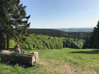
From the car park at the outskirts of Wieda (S), go back a few meters, then follow the Baudensteig along the old railway track in the Wieda valley towards Braunlage. Above the creek and the road, at the next car park turn left to the Stöberhai station (1) (refreshment stop). Here turn left, past a wildlife feeding area, ascend via the Nordhäuser Stieg to the Stöberhai (2). Here stands the "Stöberhai hut" of the Harzklub Wieda. Fantastic views towards Nordhausen, Hainleite, Bad Sachsa, Wurmberg, Brocken, etc. To the left of Stöberhai, in 1967 a 75 m high tower was inaugurated, from which the Bundeswehr watched over the GDR and Russia. It was demolished again in 2005. From the hut directly downhill through the Frankental (3) back to Wieda. Shortly before the country road, a few meters to the left to the car park.
Equipment
Normal hiking equipment, water bottle.
Whether BaudenSteig or BaudenSteig circular route, on every stage a refreshment stop and a view are guaranteed. Put on your hiking boots and go!
Directions & Parking facilities
Motorway A7, Seesen exit; B 243 to Bad Sachsa then L 601 to Wieda.
Car park at the outskirts of Wieda (on the left), L601 towards Braunlage
DB: Walkenried station; www.bahn.de; bus to Wieda Verkehrsverbund Südniedersachsen, www.vsninfo.de
Additional information
Tourist Information Walkenried, Steinweg 4, 37445 Walkenried, 05525 9989000, info@walkenried-tourismus.de, www.walkenried-tourismus.de
Author
Christian Francken
Organization
Harz: Magische Gebirgswelt
License (master data)
Map
www.harzinfo-shop.de/onlineshop/kartenmaterial
Nearby


Download GPX file