Selketal-Stieg 2: From Güntersberge (station) to Alexisbad (station)


- 3:45 h
- 14.82 km
- 151 m
- 234 m
- 318 m
- 437 m
- 119 m
- Start: Güntersberge station
- Destination: Alexisbad station

Good to know
Pavements
Best to visit
Directions
The second stage of the approximately 74 km long Selketal-Stieg leads you from Güntersberge via Straßberg to Alexisbad. From Güntersberge station, you cross the bridge towards Siptenfelder Straße and keep right. Turn into Armborst street, the re-entry to the long-distance hiking trail. Along the Selke, you hike through a former mining area. Lead, silver, copper, sulfur, and fluorspar were once extracted here. After the Elbingstalteich, you reach the junction to Hirschbüchenkopf, where stamp 173 of the Harzer Wandernadel is located. The Selketal-Stieg does not pass directly there. The path surface from Güntersberge to Straßberg varies between asphalt, forest path, and gravel, and is suitable for Nordic walking and cycling.
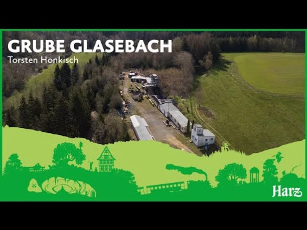
In Straßberg, you have the opportunity to stop for hospitality and enjoy Harz cuisine. Take the time to also visit the Glasebach mine. It is located about 1.5 km from the Selketal-Stieg. The mining museum houses a collection of shimmering minerals underground and shows Harz mining over three centuries. Outside the Glasebach mine is stamp point 175 of the Harzer Wandernadel. From here you can connect to the quality hiking trail HARZGERÖDER KUGELsPASS, leading you to Harzgerode.
From the stamp point at the Glasebach mine, follow the path over the meadow back to Straßberg-Glasebach station. Here you return to the Selketal-Stieg. From here, the long-distance hiking trail continues over Lindenberg towards Alexisbad.
After Rinkemühle, you pass the L234 road. On the opposite side, the Selketal-Stieg crosses a bridge a few meters through a forest section to a road. Before continuing your hike, however, a short rest at the Unterharzer Waldhof in Silberhütte is recommended. To do this, keep right, cross the railway tracks and the Selke river. The Waldhof is on the right side. Here you can learn interesting facts about forestry, hunting, mining, and wood processing. You can also admire the Trees of the Year, which are planted annually on Tree Day at the Waldhof.
Continue your hike on the Selketal-Stieg by using the hiking trail uphill at the sharp bend of the road in the direction of Uhlenköpfe, stamp point 176. After a steep ascent to the Uhlenköpfe, you can reward yourself with a view of the Brocken. The Selketal-Stieg then runs along the Nikolausweg, past Hänichen, and then continues along the Waldhofmännchenweg to Alexisbad.
At the end of the Waldhofmännchenweg, cross the road and follow the footpath towards Alexisbad. The second stage ends at Alexisbad station. Here you will find accommodation or can return by bus or Selketalbahn to your starting point in Güntersberge. As a special tip, a trip to Harzgerode is recommended, where you can visit the Erlebniszentrum Harzkugeleum at the castle and learn more about the region.
Equipment
Sturdy hiking boots, drinks, and provisions for the journey. Possibly sticks.
Directions & Parking facilities
Parking spaces are available at the Güntersberge (start) and Alexisbad (destination) stations.
Bus connections: www.insa.de
Selketalbahn runs between Güntersberge and Alexisbad: www.hsb-wr.de/Fahrplan-Tarife/
Additional information
Selketal information Harzgerode, Schlossberg 3, 06493 Harzgerode, Tel. 039484 74 76 123, stadtinfo@harzgerode.de, www.harzgerode-tourismus.de
Selketal information Ballenstedt, Anhaltiner Platz 7, 06493 Ballenstedt, Tel. 039483 263, kontakt@ballenstedt-information.de
Selketal information Gartenhaus, OT Pansfelde, 06543 Falkenstein/Harz, Tel. 034743 5 35 65, postfach@stadt-falkenstein-harz.de
www.dasselketal.de
Author
Harzer Tourismusverband
Organization
Harz: Magische Gebirgswelt
License (master data)
Author´s Tip / Recommendation of the author
Interesting sights along the way
A visit to the Glasebach mine in Straßberg is highly recommended!
In Silberhütte, the Unterharz Forest Farm offers play areas and information about the forest.
Map
Nearby


