North-South route: Bad Harzburg - Bad Lauterberg


- 8:00 h
- 66.05 km
- 1,542 m
- 1,543 m
- 288 m
- 780 m
- 492 m
- Start: Valley station of the Burgberg cable car, Nordhäuser Straße 2 A, 38667 Bad Harzburg
- Destination: Tourist information, Ritscherstraße 4, 37431 Bad Lauterberg
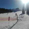
The route begins with a steep climb leading into the northern Harz mountains. Then it descends to the Oker Dam, which is one of the largest dams in the Harz. The path goes straight there, allowing strength to be gathered for the upcoming mountains. The path continues uphill to Torfhaus and then slightly downhill to Odereich. From there, it continues along ditches through the mining town of St. Andreasberg. The end of the route follows an undulating profile towards the Oder valley. The Bismarck Tower near Bad Lauterberg offers a magnificent view of the South Harz mountains.

Good to know
Best to visit
Author
VOLKSBANK ARENA HARZ / Zweckvereinbarung Mountainbike-Park Harz / c/o HARZ-Agentur GmbH / Altenauer Str. 55 (OutdoorCenter Harz) / 38678 Clausthal-Zellerfeld / Tel. 05323 982461 / info@volksbank-arena-harz.de / www.volksbank-arena-harz.de / Alle Rechte in Wort und Bild bei © Zweckvereinbarung Mountainbike-Park Harz / HARZ-Agentur GmbH. Jede Veröffentlichung bedarf der Zustimmung der Rechteinhaber.
Organization
Volksbank Arena Harz
License (master data)
Map
The Harz for mountain bikers
Through the extremely varied North German upland landscape, 74 signposted mountain bike circular routes (total length 2,300 km) lead, which are classified into three difficulty levels. Official map set "The Harz for Mountain Bikers." Completely revised and expanded new edition. The new map set consists of a route book with detachable individual descriptions and detailed maps of the routes. There is also a topographic overview map (1:50,000) on weatherproof and durable POLYART material.
ISBN 978-3-935806-28-2
Price €16.80
Publisher map solutions, Karlsruhe 2017
Nearby


