Traces into Braunlage’s past

- 3:25 h
- 13.00 km
- 176 m
- 176 m
- 513 m
- 620 m
- 107 m
- Start: At the end of Schützenstraße in Braunlage.
- Destination: like start
We start the tour at the shooting range. Along an avenue, we see a charcoal burner’s hut on the right and an explanation regarding charcoal piles, explaining how briquettes for ore smelting were made near Braunlage in the past.
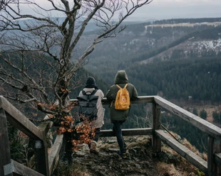
We walk 600m into the forest on the left, always uphill at the edge of the meadow until we can enjoy a great panoramic view from the Hasselkopf. We turn right to the south and walk along the forest edge to the road.
After crossing the road, on the left at the next intersection, we discover a historic "Dennert-Tanne", a signpost. We follow the "Alte Poststraße" for about 1 km and reach the "potato monument," commemorating the introduction of the potato to Braunlage in 1748 by Johann Georg von Langen, a pioneer of sustainable forestry in the Harz.
We follow the "Trübsalsweg" down to the romantic valley of the "Brunnenbach," a nature reserve. Before reaching it, we pass a beautiful spot with small fish ponds.
After following the Brunnenbach lightly uphill for 1 km, we reach the Youth Forest Home Brunnenbachsmühle after crossing the road and the stream. The building used to be the station of the former narrow-gauge South Harz railway from Braunlage. Here the track to Tanne branched off from the one to Walkenried. We follow the track a few meters along the road before turning right behind the foresters’ house into the valley of the "Schächerbach." By a small pond, where water was once stored for the ironworks, we walk romantically about 1.5 km uphill along the stream until we see the rocky "Schächerstein" on the left. It can be easily climbed from behind, and here you can experience the quiet of this special power spot.
We continue uphill on the right side of the creek. After 500m at the next intersection, we meet the Walkenried track of the former South Harz railway and follow it a bit until a large junction of paths.
Now we turn sharply right onto the historic "Kaiserweg," an ancient Harz crossing and former border. We reach a small place with an information board and seating. In the 13th century, the old settlement "Kapellenfleck" was here; the church foundation is still visible today.
We continue along the Kaiserweg for about 700 m and then turn right into the next valley, following the romantic course of the "Kronenbach," crossing it on the left at the next intersection. Now we climb a short slope and soon arrive again in the Brunnenbach valley. On the left, it is recommended to stop at the Waldcafé "Forellenteich." After resting there, we ascend the "dream meadow" over the Brunnenbach. At the top, we keep right, pass a farm with Harz Red Highland cattle, maybe spotting alpacas, and cross the Braunlage bypass road. Then just a few meters on a small asphalt road descend back to the starting point of the tour.

Good to know
Pavements
Best to visit
Directions
Equipment
The route can be comfortably walked with normal to good footwear. Hiking boots are not necessarily needed due to consistently wide paths but are recommended in wet conditions due to the risk of muddy paths.
Due to the length of the route, backpack provisions are advisable. Benches invite you to rest at several points like the potato monument, Kapellenfleck, and others.
Directions & Parking facilities
The start and end of the hike is at the end of Schützenstraße. This leads a short way uphill directly opposite Braunlage's central bus station (ZOB). Therefore, the route is ideal – even for visitors – to reach by bus.
The following lines end at the ZOB in Braunlage:
820 from Bad Harzburg (station), Torfhaus
820 from St. Andreasberg (with connections from Bad Lauterberg / Herzberg (station) and Clausthal-Zellerfeld / Altenau), weekend direct connection line 450 from Bad Lauterberg / Herzberg - Braunlage
470+472 from Bad Sachsa / Walkenried (station), Hohegeiß / Zorge, Wieda
264 from Wernigerode (station), Schierke, Elend
262 from Benneckenstein, Tanne / Sorge
Additional information
There are two stamp stations of the Harzer Wandernadel on the route: Kapellenfleck (#157) and at the Waldcafé "Forellenteich" special stamp (#9932).
Links with historical information:
Potato monument and the personality Johann Georg von Langen
former Brunnenbachsmühle station and the South Harz railway
Information about refreshments at the Waldcafé Forellenteich
Author
Jörg Kühnhold
Organization
Harz: Magische Gebirgswelt
License (master data)
Author´s Tip / Recommendation of the author
From the Hasselkopf, panorama views over Braunlage with Achtermann, Brocken, and Wurmberg in the background.
Some information boards on-site tell exciting history.
Romantic Schächerbach valley with power spot "Schächerstein."
Historic hotspot "Kapellenfleck" with "Kaiserweg."
Safety guidelines
Nearby


Download GPX file