The Hanskühnenburg

- 8:15 h
- 27.96 km
- 662 m
- 672 m
- 226 m
- 810 m
- 584 m
- Start: Bleichestelle car park, Scheerenbergstraße (next to the fire station), 37520 Osterode
- Destination: Bleichestelle car park, Scheerenbergstraße (next to the fire station), 37520 Osterode
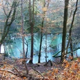
A hike to the Hanskühnenburg and along the Acker ridge is an experience all year round.
If you feel hungry or thirsty once you reach the Hanskühnenburg, you can indulge yourself with hearty meals in the forest inn in the national park from 9 a.m. to 5 p.m. (from November to March from 9 a.m. to 4 p.m.). From the observation tower of the Hanskühnenburg, you have a wonderful view over the southern Harz foreland and to the Brocken.

Good to know
Pavements
Best to visit
Directions
We start our route at the Bleichestelle car park. From there, the path leads over the black bridge along the fishing educational trail (towards Riefensbeek) to the forebay. We cover 9 km of distance up to that point. From the forebay, it goes directly to the Hanskühnenburg, which invites you to a generous rest. The observation tower should definitely be climbed. Via a detour on the Acker, we take the same way back to Osterode.
Insider tip on the side: The name “Ackerblick” actually has nothing to do with the agricultural field – it comes from the Middle High German “agger,” which means ridge or embankment – exactly the geographical shape of the Acker ridge.
Equipment
The path to the Hanskühnenburg is very steep and should only be tackled with good footwear.
Directions & Parking facilities
Coming north on the A7: Take exit 70-Northeim West and follow the B241.
Coming south on the A7: Take exit 67-Seesen/Harz and drive on the B248 towards Osterode.
Free parking is available at the Bleichestelle (Scheerenbergstraße next to the fire station) in Osterode am Harz.
If you arrive by train, choose the Osterode Mitte stop.
If you arrive by bus, get off at the Osterode bus station.
Additional information
If you have any questions, you are welcome to contact the Osterode tourist information.
Phone number: 05522- 318333
Literature
Leisure hiking, cycling, motorcycling and tips from the Osterode am Harz region: Ahead mountains
Author
Britta Nause
Organization
Harz: Magische Gebirgswelt
License (master data)

Map
Harzer Baudenstieg hiking map GPS-precise Publisher: Publicpress - The maps with the sun ISBN: 978-3-89920-626-5 or Harzer Hexen Stieg official map for the recognized prestigious hiking trail in the Harz issued by the Harz Tourism Association and the Harz Club e.V. Publisher: Schmidt Book / Cartography
Nearby