Harzer-Hexen-Stieg - 3rd stage - from Torfhaus to Drei Annen Hohne

19.73 km long
Difficulty: medium
Condition: medium
Great panorama
Walking / hiking
  • 5:00 h
  • 19.73 km
  • 341 m
  • 599 m
  • 542 m
  • 1,141 m
  • 599 m
  • Start: Torfhaus
  • Destination: Drei Annen Hohne
The "highlight" of the route: This stage leads through the Harz National Park to the 1141 m high Brocken, the highest mountain of the Harz and all of northern Germany.

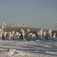
The 1142 meter high Brocken summit appears within reach from the starting point Torfhaus. Hexen-Stieg and Goetheweg are one and the same; along it we hike towards the most German of all mountains. At the signposts of the national park, the wooden green witch shows us the right path.
Here, along this slab path, once lay the border that divided Germany for over 40 years. That is history. Today we pass through the most beautiful raised bogs of the Harz National Park up to the highest summit of northern Germany, with an incomparable view. Schlungsklippen, Ahrensklint, Trudenstein: above Schierke, the path leads past rugged rocks and through dense forests to our stage goal, directly at the station of the Harz narrow-gauge railway.

Harz: Magische Gebirgswelt

Good to know

Pavements

Unknown
Gravel
Trail

Best to visit

suitable
Depends on weather

Directions

Arriving at Torfhaus, the landscape opens up again, with a magnificent view of the highest peak of the Harz, the Brocken. It used to lie unreachable between East and West. Today, we cross the former Iron Curtain on the comfortable “Goetheweg”, which has since become the Green Belt. Every now and then, the steam trains of the Harz narrow-gauge railways thunder past, bringing those not keen to hike up to the mountain. The fantastic panoramic view from the 1141 meter high Brocken summit is well worth the climb. But even in fog, which is not uncommon, the mountain is an experience. Alpine plants grow in the Brockengarten; in the Brockenhaus there are interesting exhibits about the mountain and its history. The highest point of the Hexen-Stieg has been reached. Now it goes downhill, at least as far as the terrain is concerned, but it remains exciting. Or have you already heard about the impressive “Wollsack weathering” of the Brocken granite, which Goethe had already described? At Ahrensklint, the Feuerstein cliffs, and the Trudenstein above Schierke, you can stand on it!

Schierke, in the “Valley of the Witches”, has a long tourist tradition. The “St. Moritz of the North” was and still is a popular winter sports resort. Numerous old half-timbered villas exude their charm. The town at the foot of the mountain is one of the most frequent starting points for hiking to the Brocken. But we walk down on quiet paths, because the Hexen-Stieg passes above the town, through fresh forest to the hamlet of Drei Annen Hohne.

Directions & Parking facilities

The Altenau district Torfhaus is easily accessible by car via the B4 from the north via Bad Harzburg and from the south via Braunlage.
At Torfhaus there is a paid large parking lot.
The Torfhaus is located directly on the bus line Bad Harzburg - Braunlage.

Literature

KartoGuide Harzer Hexen-Stieg Official guide with map (1:30,000) Authors: Hans Bauer & Dr. Stefan Krooß Publisher: Harzer Tourismusverband & Harzklub Publishing house: Schmidt-Buch-Verlag, Wernigerode ISBN-10: 3936185336 ISBN-13: 978-3936185331 Price: €6.80

Author

Andreas Lehmberg

Organization

Harz: Magische Gebirgswelt

License (master data)

Map

Harzer Hexen-Stieg 1 : 30,000: Official map of the recognized premium hiking trail in the Harz. Publisher: Harzer Tourismusverband & Harzklub Publishing house: Schmidt-Buch-Verlag, Wernigerode ISBN-10: 3936185328 ISBN-13: 978-3936185324 Price: €5.50

Nearby