- 3:46 h
- 12.59 km
- 320 m
- 240 m
- 611 m
- 878 m
- 267 m
- Start: Sandbrinkstraße, 38879 Schierke
- Destination: Schierke village area via hiking trail D18
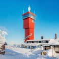
Parking garage at Winterbergtor - Yellow Trail - Sandbrinkstraße - Dead End - Black Bridge - 400m steep ascent, Kolonnenweg left to the large Winterberg (907m above sea level).
From here, connection to the cross-country trails in West Harz - to Schierke via hiking trail D 18 (length 12.5 km)
DSV Premium cross-country trail
This trail is a certified DSV Premium trail .
Together with the authorities in Schierke, the Safety in Skiing Foundation (SIS) and the German Ski Association (DSV) have worked in recent years for a qualitative development of the trail network in the Harz. The trails were certified as DSV nordic active centers according to international criteria , marked with a uniform system and equipped with information boards.

Good to know
Pavements
Best to visit
Directions & Parking facilities
Parking garage "Am Winterbergtor"
Winterbergtor parking for cars up to 2 meters height
700 covered car parking spaces, toilets
Charging station for electric cars
The town center with the Tourist Information can be reached via a pedestrian bridge. Cross-country ski trail and hiking trail start (National Park, Brocken) are right at the parking garage. Bus stop directly at the entrance/exit of the parking garage.
Additional information
Tourist Information Schierke
Brockenstraße 7 A'
38879 Wernigerode OT Schierke
Tel. 039455 8680
info@schierke-am-brocken.de
www.schierke-am-brocken.de
Author
Harzer Tourismusverband
Organization
Harz: Magische Gebirgswelt
License (master data)

Map
Map material is available at Wernigerode Tourismus GmbH / Tourist Information Schierke (Brockenstraße 7A, 38879 Wernigerode OT Schierke).
Nearby