Paths to the Brocken - Ascent from Schierke


- 1:55 h
- 5.41 km
- 504 m
- 2 m
- 634 m
- 1,142 m
- 508 m
- Start: Schierke, Brockenstraße
- Destination: Brocken
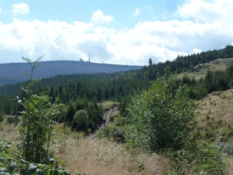
For experienced and well-equipped hikers, the scenic ascent from Schierke through the Eckerloch to the Brocken is recommended. The rustic hiking trail begins a few meters behind the National Park House at the waterworks. With good footwear, this route over roots, rocky granite, and boardwalks is a true pleasure. Here you can especially well experience the forest in transition. The path follows the rapids of the Schwarzes Schluftwasser down to the Eckerloch wetland. The Eckerlochstieg leads into the Brockenstraße, which then takes the hiker to the summit.

Good to know
Pavements
Best to visit
Directions
Schierke, National Park House - Eckerlochstieg - Brockenstraße - Brocken
Equipment
Sturdy footwear, weather-appropriate clothing.
Directions & Parking facilities
Via B27 at Elend, then via L99 to Schierke or L100 coming from Drei Annen Hohne.
Various parking options in town such as the paid Brocken Schierke parking lot or the paid "Am Winterbergtor" parking garage.
Bus line 257: Wernigerode - Braunlage (via Elbingerode, Königshütte, Schierke, Mandelholz, Elend)
From the Brocken: With the Harz narrow-gauge railways to Wernigerode, Drei Annen Hohne or Schierke
Additional information
Tourist Information Schierke
Phone: 039455 8680
info@schierke-am-brocken.de
www.schierke-am-brocken.de
https://www.harzinfo.de/erlebnisse/wandern/die-wege-zum-brocken
Author
Harzer Tourismusverband
Organization
Harz: Magische Gebirgswelt
License (master data)

Safety guidelines
Surefootedness required
Map
The Hochharz - Around the Brocken (standard) hiking and cycling map scale 1 : 30,000, UTM grid for GPS, contour lines in 20 m intervals, Harz Club hiking trails format 110 x 200 mm, 990 x 600 mm (open) standard edition (map paper) ISBN 978-3-928977-91-3 Price: 4.00 €
Nearby
")