Oderteich circular route


- 1:05 h
- 4.39 km
- 18 m
- 18 m
- 718 m
- 736 m
- 18 m
- Start: Oderteich parking lot, Oderbrück
- Destination: Oderteich parking lot, Oderbrück
The Oderteich is circled once on idyllic paths, rooty trails, and rustic boardwalks. You can stamp your Harzer Wandernadel hiking pass at the Sonnenkappe.

Good to know
Pavements
Best to visit
Directions
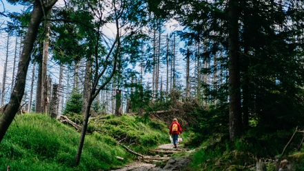
We first hike along the east shore through a very old forest. It has not been managed long before the founding of the national park. Here are some of the oldest spruces in the Harz National Park, some over 300 years old.
We are in an area where the trees are gradually dying. The reasons for this are, besides the bark beetle, persistent drought and storms, waterlogging, which slowly creates a marshy area where few plants can grow. These specialists are well adapted to the marsh habitat. Many mosses are found here, as well as the round-leaved sundew. Since a normal path would damage the sensitive biotope, the path runs over a boardwalk.
The path then leads us a little away from the shore through a forest area. Near the path are some fences where tree species like birch, rowan, and beech have been planted. The goal of this planting is to supplement the prevailing spruces with deciduous trees. This allows nature to develop into a mixed forest. The fences protect the young deciduous trees from wildlife, for whom the fresh shoots are a special delicacy.
On the north shore, we cross the Oder inflow to the reservoir. The Oder springs east of Oderbrück in a marshy area. There, the water is stored like a sponge and released only slowly. Over time, the Oder has carved its way through the Oder valley, which continues below the dam.
After another short stretch, our circular route turns south and follows the Sonnenkappe stream, which meanders on its way to the reservoir. It is worth spending a moment on the benches set up here to enjoy the view of the opposite shore. In the edge areas of the forest, you will see many young deciduous trees. Especially rowan, birch, and some willow species grow well in these lighter areas.
Along the west shore, old drainage ditches have been closed with small dams. This slows down the artificial water outflow, and the vegetation typical for this location slowly returns – trees die, mosses, and plants adapted to waterlogging settle in.
After a short stretch on the forest path, we turn left again toward the shore. Here, a rest area invites you to refresh. From here we are again in the bathing area. After a few hundred meters, our circular route ends at the dam.
Directions & Parking facilities
Parking lot "Oderteich" on B 242, 37444 St. Andreasberg
Oderteich bus stop
Additional information
National Park Visitor Center TorfHaus,
Tel. 0 53 20 / 33 17 90, www.torfhaus.info
National Park House Sankt Andreasberg,
Tel. 0 55 82 / 92 30 74,
www.nationalparkhaus-sanktandreasberg.de
Organization
Nationalpark Harz
License (master data)

Safety guidelines
Dogs must be kept on a leash in the national park area (including on this route).
Nearby


Download GPX file